Reading a City Map Through Its Edges
Reading a city map through its edges helps you spot natural boundaries, transport corridors and neighborhood shifts before choosing where to explore.
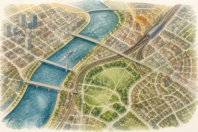
The common mistake when reading a city map is to start with individual attractions and treat the streets between them as blank space. That can leave you choosing places on opposite sides of a river, rail corridor or sprawling park without noticing how the city’s layout shapes the day. Reading a city map through its edges gives you a broader picture before you commit to a neighborhood or route.
What can a city’s edges tell you?
Edges reveal where movement may be easy, awkward or concentrated. A river can divide districts while bridges funnel crossings into a few locations. A rail line may connect distant areas but interrupt short walks across it. A large park can offer a calm route through the city or create a gap between nearby-looking streets.
Think of these features as the seams in a piece of clothing: they show how separate parts fit together, even before you inspect every detail. They do not tell you whether a place is worth visiting. They help you ask better questions about access, neighborhood shape and the likely feel of moving between places.
Begin with a map zoomed out enough to show the city center and surrounding districts. Then identify the major physical and built features before zooming in on streets. This order helps you avoid mistaking a straight line on the screen for a simple route on the ground.
How does a river change the way you read a map?
A river marks a clear boundary, but its effect depends on how often and where people can cross it. Look for bridges, pedestrian crossings, ferries and roads that approach the water. If crossings cluster far apart, two neighborhoods that appear close may require a long detour.
Notice what sits along each bank. One side may have a continuous waterfront path, while the other is bordered by warehouses, steep slopes or major roads. The map can show these differences through labels, path markings and street connections, though it cannot fully convey noise, access restrictions or how inviting a route feels in person.
Trace a possible crossing before choosing a riverside destination. If the map shows several bridges, compare which one connects most directly to the streets you want to explore. A bridge that appears central may carry fast traffic and have limited pedestrian access; a nearby footbridge may make a more comfortable crossing.
What do rail lines and stations reveal?
Rail lines often reveal both a city’s travel corridors and its barriers. A line with frequent stations can anchor a chain of neighborhoods, while elevated tracks, rail yards or cuttings may separate streets that otherwise appear to meet. Check whether roads and walking paths cross the tracks at regular intervals or only at a few underpasses and bridges.
Stations can also mark local centers. A cluster of shops, civic buildings or street names around a station may suggest a useful place to pause or change direction. Do not assume every station sits in the middle of an easy-to-walk district: some serve large interchange complexes, edge-of-center locations or areas with wide roads between the platforms and nearby streets.
Separate the line’s role as a boundary from its role as transport. A rail corridor may make a short walk inconvenient but offer a direct ride to another area. For a trip focused on exploring on foot, inspect the crossings; for a trip that links distant districts, note the stations and the streets that connect them to places you may want to see.
How should you read a large park on the map?
A large park can be a destination, a shortcut or an obstacle, and the map’s paths help distinguish among those roles. Look for entrances, through-paths and routes that connect opposite sides. A green area with several mapped paths may provide a pleasant crossing; one with paths concentrated at the perimeter may require you to walk around it.
Check how the streets meet the park boundary. A main gate on one side does not mean that every edge is open, and a path shown inside the park may not connect to the street where you need it. Pay attention to roads, waterways and fenced facilities within the green space, which can break a route into separate sections.
Imagine you are choosing between a museum on one side of a park and a market on the other. If the map shows a continuous public path between their entrances, the park may make the journey part of the exploration. If the route exits at a distant gate, the map suggests planning around the park instead of assuming it works as a shortcut.
What can changes in the street pattern tell you?
Street patterns offer clues to how neighborhoods developed and how they connect. A tight grid usually gives you several route options and frequent turns. A pattern of curved streets and cul-de-sacs may indicate a residential area where reaching a nearby main road takes longer than the map’s straight-line distance suggests.
Look for where one pattern changes into another. A regular grid that bends around a hill, meets a riverfront or gives way to broad avenues marks a transition worth noticing. These shifts can help you divide the city into walkable areas rather than treating the whole map as one continuous texture.
Street labels and map symbols add context. A wide avenue may be an important connector but less pleasant for lingering; a narrow lane may be attractive but restricted to pedestrians or local access. Use the map to identify possible routes, then check current signs or local information when access matters. Where a route depends on a provider’s rules, a map label or local restrictions, follow those instructions.
Which map questions help you read a city’s edges?
How can I tell if a river crossing is practical?
Look for a mapped pedestrian route across the water and check which streets it joins on both banks. A bridge symbol alone may not show whether walking access is available, so inspect the map legend and available route details before relying on it.
Does a rail line always mark a neighborhood boundary?
No. Stations and frequent crossings can make the corridor a strong connection, while a long stretch without crossings can divide nearby streets. Check the pattern of roads and paths around the section you expect to use.
Can I assume a park path is open to through-walkers?
No. A mapped path may serve a limited entrance, a facility or a route with restricted hours. Check the park’s posted information or local map if the crossing is central to your plans.
What should I inspect after noticing a street-pattern change?
Look for the roads, stations or public spaces that connect the two patterns, then compare the walking routes between them. A change in street layout may signal a natural boundary, a major road or simply a different neighborhood design.
How do you turn map clues into a useful area choice?
Choose one broad area by considering its boundaries, crossings and street connections together. You might favor a district with several nearby streets to explore, or one that is easy to reach by transit and has a clear route from the station. The best choice depends on whether you value easy walking, variety or a particular kind of place.
For a simple planning pass, mark the features that affect your likely movement:
- Water: Locate bridges, ferries and public paths before selecting places on opposite banks.
- Rail: Note stations and the nearest crossings where you may need to walk across a corridor.
- Green space: Check entrances and through-paths instead of assuming the park is open from every side.
- Street pattern: Spot grids, winding residential streets and sudden changes in road scale.
- Connections: Trace how the area joins the next district by foot, transit or a direct street route.
Imagine you have an afternoon free and two places in mind: a gallery across a river and a market beside a station. On a zoomed-out map, you notice that the nearest bridge is well away from the gallery, but a rail station on the gallery’s bank links directly to the market area. You could then compare a transit connection with a longer riverside walk, choosing the route that suits your available time and interest rather than relying on apparent map distance.
Reading a city map through its edges is most useful when you treat each feature as a question, not a verdict. Rivers ask where crossings are; rail lines ask whether they connect or divide; parks ask whether paths pass through; street changes ask how one district leads into another. Once those answers are visible, you can choose an area that fits the kind of exploration you want and leave room for the city to surprise you.